The Falls by Sunrise with the Spray Cloud Rising 1,200 Feet
THE MOSI-OA-TUNYA *), OR VICTORIA FALLS, ZAMBESI,
by Thomas Baines.
*) This name may be pronounced nearly as Mosi-wa-tunya (“The Smoke that Thunders”).
THE popular idea of Africa has long been that its interior was a vast desert. The traditions of inland waters were discredited, and in 1849 Lake Ngami was erased from our maps, at the time it was being discovered in the very place native report had assigned to it.
Nevertheless, those who held communication with the half caste traders, or had access to the early Portuguese records, knew that extensive lakes and river systems were to be found there.
The Leaping Water or Westernmost Cataract
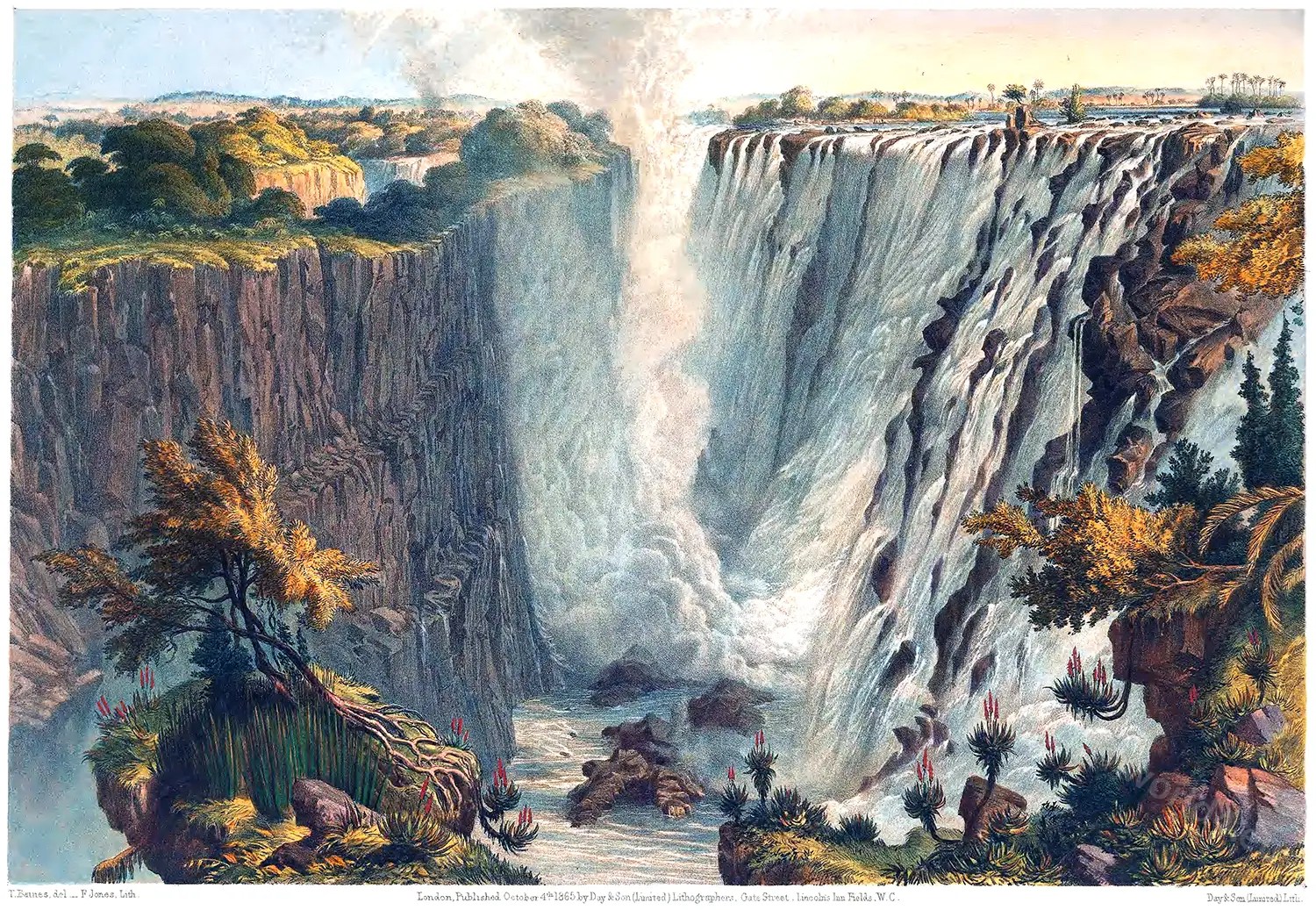
The Falls from the Western End of the Chasm
In Ogilby’s Africa, published in 1670, the map shows two great lakes nearly corresponding with the Victoria and Albert Nyanzas, with branches of the Nile flowing from them, and the Zambesi is given nearly in its true position, though the Manice or Rio de Spirito Santo is erroneously connected with it. The Atlas Geographus, in 1714, less correctly even than the earlier record, describes the Lake Zambre as the common source of the Nile, the Cuama (or Zambesi), the Manice, and the Zaire or Congo, on which are “cascades in the middle of its channel falling from rocks with a noise that may be heard two or three leagues off.”
Great Western or Main Fall, from Three Rill Cliff to Garden Island
It has for some time been known that within the southern tropic, and nearly equidistant between the eastern and western coasts, the course of the great river Zambesi was interrupted by similar falls; and in 1852 or 1853 my long-known and highly-esteemed friend Mr. James Chapman, who crossed the continent of Africa in those years, had engaged a canoe, and was embarking for a visit to the Falls, when the crew were recalled by Sekēletu, their chief, and he was obliged to forego the honour of being their discoverer.
Herd of Buffalos drives to the Edge of the Chasm. Opposite Garden Island.
In 1855 they were seen by Dr. Livingstone *), who was then preparing for his journey to the east coast, and was the first to bring them to the notice of the British public.
*) David Livingstone (1813 -1873) was a Scottish missionary and an African explorer. From 1853 to 1856 he crossed the whole of South Africa from the Zambezi to Loanda (Luanda) and back to Quelimane. In November 1855, he discovered the Victoria Falls of the Zambezi for Europe.
Centre Rock Fall and the Eastern Cataracts.
Various branches of the Zambesi appear to rise not far from the west coast, and flow through a country so level that they give off, as well as receive, other streams, of which it seems probable “that the Okovango river (also Cubango), discovered in 1859 by that enterprising traveller and naturalist Mr. C. J. Andersson *), is one of the principal, till the river reaches nearly the centre of the continent.
*) Charles John Andersson 1827-1867, was a Swedish adventurer, explorer, trader and writer who was involved in the exploration and development of South West Africa, now Namibia..
The Falls from the East End of the Chasm to Garden Island.
Here the Falls are formed by a deep narrow chasm cleft across the broad bed of the river, which, plunging 400 feet into the abyss, escapes by another cleft joining the first at nearly three-fourths from its western end, and prolonged in abrupt zigzags and redoublings for many miles, engulfing the narrow lower river far below the surface, occasionally spreading out and again contracting; traces of the fissure appearing, as it seems to me, nearly to the Indian Ocean, or more than 800 miles away.
Zanjueelah, the Boatman of the Rapids.
The Falls from the Narrow Neck Near the Eastern Headland of the Outlet.
Above the Falls, where the river is nearly on a level with the surrounding country, rich tropical vegetation abounds, and long reaches are descended on rafts or navigated in canoes, almost the only difficultcy being occasioned by the thick growth of reeds in the shallower portions.
Below them no continuous navigation is possible for eighty or a hundred miles; but beyond this long open reaches alternate with occasional rapids and narrow gorges, the most dangerous being those of Chiawa and Kabrabasa, in which my friend Dr. Kirk, when descending the river, very narrowly escaped drowning.
The Profile Cliff, Narrow Gorge and Torrent of the Zambesi, below the Falls.
In presenting to the public the accompanying views of these magnificent Falls, I presume not to compete with the works of those who have so beautifully illustrated more accessible countries. In the far interior of Africa, an artist must leave behind him every convenience, and becoming in turn smith, carpenter, tailor, and shoemaker, bullock-driver, and astronomical observer, must obtain his sketches and finish his pictures as he can, trusting that any want of artistic finish may be compensated by the faithfulness inseparable from working as much as possible in the actual presence of nature.
The Falls by Sunrise with the Spray Cloud Rising 1,200 FeetThe Falls from the Western End of the ChasmGreat Western or Main Fall, from Three Rill Cliff to Garden IslandHerd of Buffalos drives to the Edge of the Chasm. Opposite Garden Island.Centre Rock Fall and the Eastern Cataracts.Zanjueelah, the Boatman of the Rapids.The Falls from the East End of the Chasm to Garden Island.The Falls from the Narrow Neck Near the Eastern Headland of the Outlet.The Profile Cliff, Narrow Gorge and Torrent of the Zambesi, below the Falls.The Victoria Falls. Zambesi River by Thomas Baines, 1865.
Source: The Victoria Falls, Zambesi River: sketched on the spot (during the journey of J. Chapman & T. Baines), by Thomas Baines (1820-1875); J. v. Heryng. London: Day & Son, limited, lithographers & publishers, 1865.
To provide the best experiences, we use technologies like cookies to store and/or access device information. Consenting to these technologies will allow us to process data such as browsing behavior or unique IDs on this site. Not consenting or withdrawing consent, may adversely affect certain features and functions.
Functional
Always active
The technical storage or access is strictly necessary for the legitimate purpose of enabling the use of a specific service explicitly requested by the subscriber or user, or for the sole purpose of carrying out the transmission of a communication over an electronic communications network.
Preferences
The technical storage or access is necessary for the legitimate purpose of storing preferences that are not requested by the subscriber or user.
Statistics
The technical storage or access that is used exclusively for statistical purposes.The technical storage or access that is used exclusively for anonymous statistical purposes. Without a subpoena, voluntary compliance on the part of your Internet Service Provider, or additional records from a third party, information stored or retrieved for this purpose alone cannot usually be used to identify you.
Marketing
The technical storage or access is required to create user profiles to send advertising, or to track the user on a website or across several websites for similar marketing purposes.