Syria during the period of the crusades, 1096-1291.
The principality of Antioch. The crusades.
OF the four leading states founded by the Crusaders in Syria, the principality of Antioch was the most northerly and the kingdom of Jerusalem the most southerly. The county of Tripoli lay between these two extremes, while to the northeast, on either side of the Euphrates, lay the county of Edessa.
The county of Edessa.
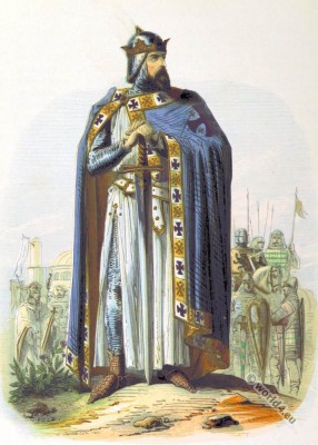
The county of Edessa, founded by Baldwin of Boulogne (1058-1118), the brother of Godfrey de Bouillon (French: Godefroy de Bouillon; also Godefroid de Bouillon; 1060-1100, after the conquest of Jerusalem, he became the first ruler of the newly established Kingdom of Jerusalem, but rejected the kingship.), dates from 1098. Originally it was not a fief of the kingdom of Jerusalem, since it was established before the taking of the Holy City. On Godfrey’s death Baldwin was elected king, and endowed his cousin Baldwin du Bourg with Edessa and its dependencies. Thus Edessa became a vassal state to the kingdom of Jerusalem.
On BALDWIN I’s death BALDWIN II became King of Jerusalem, and in his turn handed over Edessa to his kinsman Joscelin de Courtney, from whom it passed to his son Joscelin II. In 1144, at Christmas, the town of Edessa was taken by Imad ad-Din Zengi, and, though recaptured by Joscelin for a few months towards the end of 1146, almost immediately fell back into Muslim hands.
The rest of the county, ‘ground’ (in William of Tyre’s words) ‘between the two millstones,’ Masud, Sultan of Iconium, towards the north, and the Atabegs of Aleppo and Mosil towards the south, was finally abandoned by the Crusaders in or about the year 1152. Nominally the deserted cities were handed over to the Greek Emperor, whose power however in these parts was very feeble, and they soon drifted into other lordship.
The principality of Antioch.
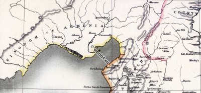
The principality of Antioch was founded by Bohemond I in 1098-99. From the earliest times it was a bone of contention between the Greek Emperors and the Kings of Jerusalem. Twice at least (1137 and 1142) did John Comnenus (Byzantine Emperor from 1118 to 1143) come south to enforce his claim; and once Manuel Comnenus, his son, led an army to Antioch for the same purpose.
The principality extended northwards as far as the river Gaihun (Aras or Araxes River), and southwards to the river that flows ‘between Margat and Valenia,’ perhaps the modern Burğ es -Sabī, or, according to Ray, the modern Wady Mehica, where the county of Tripoli commenced. Eastward its boundaries were vague and fluctuating. In the twelfth century the Armenians began to show signs of activity in the neighbourhood of Cilicia, and conquered Tarsus from the Greeks for a time in 1132.
At first they were more or less dependent on the Princes of Antioch; but at last, about the year 1193, they established their independence and fixed the limits of their state, towards the south, at Portella. Leo of Armenia was now definitely set free from his homage to the Prince of Antioch, and in 1198 or 1199 was crowned King of Armenia by the Archbishop of Mentz acting in the name of the German Emperor. Baibars the Sultan of Egypt took Antioch, May 27, 1268, and immediately after this the Templars abandoned their two fortresses to the north of this city and ‘all the land of Port Bonnell at the entering in of Armenia.’
The county of Tripoli.
The county of Tripoli was bounded, on the north, by the principality of Antioch; and, on the south, by the Nahr Ibrahim, or Adonis. It was practically established by Raymond of St. Gilles (who died in 1105); but Tripoli itself was not taken till 1109. On its east lay the territories of the Assassins. Raymond III (otherwise known as Raymond II), dying in 1189 without issue, left his lordship to his godson Raymond, eldest son of Boamund III of Antioch.
After a somewhat confusing tangle of events the county of Tripoli and the principality of Antioch were both united in the person of Boamund IV (ob. 1232), and remained in the hands of his descendants till the final fall of both cities, Antioch in 1268 and Tripoli in 1289.
The kingdom of Jerusalem.
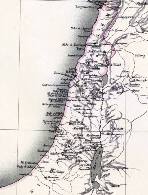
The kingdom of Jerusalem properly so called extended, at the time of its fullest development, from the Nahr Ibrahim to El-Arish on the confines of Egypt (beyond the limits of the map). According to the traditions of the thirteenth century, it was subdivided into some twenty-one greater fiefs, each owing a specified number of knights and sergeants to their overlord the king. These fiefs are: (I) Jaffa and Ascalon; (2) Ramla or Rames; (3) Ibelin; (4) the’principality’ of Tiberias, including the city of Tiberias and the stronghold of Safed (Saphet); (5) the lordship of Sidon and Beaufort; (6) of Caesarea; (7) of Beisan; (8) of Kerak and Montréal beyond the Jordan and Dead Sea; (9) of St. Abraham or Hebron; (10) of Blanchegarde, i.e. Tell es-Safi; (11) the bishopric of Lydda; (12) the lordship of Arsuf; (13) of Haifa; (14) and of Caymont; (15) the archbishopric of Nazareth; (16) the’fief of Count Joscelin’ (probably between Tiberias and Acre or Sidon); (17) the lordship of Scandelion; (18) of Tyre; (19) of Toron or Tubnin; (20) of Belinas or Caesarea Philippi; (21) of Beirut. It is obvious however that this list is made up of heterogeneous elements, and it is hardly possible that all these fiefs can have existed at one and the same time (In the map the name Dera, east of Adratum, should be omitted.).
List of places and names.
In the following list of places alternative names have been placed side by side for the convenience of those using the contemporary narratives.
Accaron, Acre, Ptolemais.
Accaron, Ak’-a-ron, Ekron, now the small village Akir, 4 miles east of Ibelin.
Adratum, Adrach, sive Hadrach, alias Adra, Adraon, 23 miles north-west of Bostra.
Alba Specula, or Blanch-garde. Alba Specula for “White view” is a Crusader fortress in Israel today. The castle lies on the Tell es-Safi, the ancient Gath, about halfway between Jerusalem and Ashkelon. The settlement mound called themselves the Crusaders Mons Clarus (“bright mountain”).
Arnoldi Castrum, probably El-Burg, between Jaffa and Jerusalem. (On July 10th of the year 1192, Richard the Lionheart breaks from Ashkelon, and comes to the castle Arnoldi at Yalu, who erected in 1132 the Crusaders. There he spends a night. The next day, he set up his camp near Beit Nuba. Here the Crusaders are supplied for the next three weeks with provision and supply of weapons. In the meantime, Richard the Lionheart undertakes a series of raids in the direction of Jerusalem. One of the eyewitnesses of the events is the Cistercian Rudolf of Coggehale. He describes how the King Richard arrives with his army to Castrum Arnoldi and after Bethonople at Emmaus. “Cumque rex cum exercitu suo devenisset ad castellum Ernoldi et ad Bethonople juxta Emmaus”.)
Barin, Mons Ferrandus, Montferrand, east of Tripoli near the place Barin (بعرين). The castle was built in the 1100s by Raymond of St. Gilles.
Beauvoir Castle, modern Kaukab al-Hawa, 6 miles north of Baisan. It was built within the ruins of the Crusader fortress of Belvoir, from which it expanded. The Crusader names for the Frankish settlement were Beauvoir, Belvoir, Bellum videre, Coquet, Cuschet and Coket.
Betenuble, Bayt Nūbā, modern Bayt Nuba (Arabic, بيت نوبا..) The biblical city of Nob mentioned in the Book of Samuel.
Bochée, La, valley eastward of Crac des Chevaliers.
Bombrac, Al-Khayriyya, 4,5 miles east of Jaffa. Mentioned in 1191 in the Itinerarium Regis Ricardi of King Richard I of England.
Caco, modern Kakan, south-east of Caesarea.
Camolla, Camela, Emesa, Hims.
Casal Imbert, the modern Khurbet Hamsin, some 9 miles north of Acre and 2 miles from coast near the village Az-Zeeb or al-Zib. Mentioned in the Bible by its ancient name Achzib. Casal Imbert also Casale Huberti de Paci, Casale Lamberti, is the ruins of a Crusader fortress, in Israel. Casal Humberti, after Hubert of Pacy which held the casale and is documented in 1108.
Casella de Planis et Casella Maen, identified by Bishop Stubbs with Beit-Degan (6 miles south-east of Jaffa) and Safirlya (7 miles south. east of the same place). Others would identify ‘Casal of the Plains’ with Kalansuwa.
Casellum Balneorum near Ramla, according to Bishop Stubbs Amwas or Emmaus.
Cavea Roob, cave-fortress, obviously between the Jordan and Adratum, Gadara and Adraat. L. Oliphant states that the upper valley of the Wady Shellaleh, in his belief, still bears the name of Wädi er-Rahüb. If this be so, Cavea Roob lies a few miles to the south or south-east of Mezarib.
Caymont, modern Tell Keimun, 12 miles south-east of Acre, 11 miles from coast.
Cisterna Rotunda, Khuwailija, southeast of Gaza.
Crac des Hospitaliers, Crac des Chevaliers, south-east of Tortosa.
Crac de Montréal, Shobek or Mons Regalis,- see the inset map.
Crac de la Pierre, Kerak, east of the Dead Sea.
Destrictum, Les Destroits, or the modern Dustrey, about 1 mile east of Athlit.
Emmaus, Ammaum, Emmaous, modern Amwas, Roman-Byzantine city of Nicopolis and perhaps medieval Castellum Balneorum.
Fémie, Apamea or Afamiya. Frontier fortress of the Principality of Antioch to the north of Hamah.
Forbelet,le, probably the Arabic Aferbela. Afrabalā-Forbelet et L‘Ophra de Gédéon (Joshua 18.11-28). Rey would make it the modern Kalat Maleh close to Baisan, Forbia, modern Herbiya, 8 miles northeast of Gaza and about 2 miles from the coast.
Gadara, 7 miles east of the Jordan and 25 miles west of Adratum,
Galatia, Galatie, according to Bishop Stubbs Karatiya, 10 miles east of Ascalon; others make it Gelediya, about 3 miles north of Karatayya.
Gaston, a castle to the north or northwest of Antioch; according to Rey it is Capt. Marmier’s ‘Chateau du Fils’; it clearly lay between Antioch and Portella.
Gaudii Mons, Nebi Samwil, 5 miles north-west of Jerusalem.
Gerasa: see Jerras or Jerash.
Gistrum, according to Riant and Hagenmeyer Hisn-el-Gisr, the fortress which commands the bridge across the Orontes at Caesarea.
Hatab, Ain-Tab, north of Aleppo.
Hrom-gla, Qal’at ar-Rum, Forteresse de roum: see Ranculat, Rum-Kalah.
Imbert, Casal, Casale Huberti de Paci, Casale Lamberti: see Casal Imbert.
Jacob Vadum, the modern Bridge or Ford of Jacob’s Daughters (sir Banat Yakub), just to the south of the spot where the Jordan issues from the Waters of Meron.
Jerras (Jerash, Gerasa, Dscharasch), 36 miles northeast of where the Jordan leaves the Dead Sea and 30 miles south-west of Adratum.
Kharput, or Kharpet “rocky fortress”, south of the Murad Su or Upper Euphrates, about 50 miles north-east of Melitone.
Kharrouba, El, probably the modern Kharraibie, about 10 miles south-east of Acre, and 7,5 east of Haifa.
La Liche, Laliche, Laodicea, Ladakia, al-Ladhqiye.
Lubieh, 6,5 miles west of Tiberias.
Markab castrum = Margat, north of Tortosa.
Medan (Campestria, or plain of) is apparently the plain or table-land adjoining Mezarib, In the map it has accidentally been marked as a town. L. Oliphant would identify it with the district south or south-west of Mezarib. There is a Wady el-Medan marked on the Palestine Exploration Fund’s maps, at about 2 miles south-west of this town.
Mergesaphar, Mergzsafar, or Marcisophar vallis. The eastern Merg-es-Suffar lies, according to Wetzstein, near the northwest border of the Hauran in Gaulan. It was plainly between Salome and Damascus.
Messaara, probably the modern Meshghurah, about 17 miles east of Sidon to the west of the river Litany. (The delineation of the Lower Buka’a rests upon Maundrell’s route from Saida by Meshghurah, el-Kur’iln, and Jubb Jenin and Aithy to Damascus; Burckhardt’s route from Zahleh to ‘Anjar and Hasbeiya, the notices of which are not very accurate; and that of the same traveller from Bartik by Kefareiya, Jubb Jenin and Aithy to Damascus. Berghaus’ Memoir, p. 26. Also: Robinson, Edward. (2013). pp. 543-4. Biblical Researches in Palestine, Mount Sinai and Arabia Petraea (Vol. 3). London
Mirabel, Mejdel Yâbâ, crusader castle Migdal Tsedek. The ruins of a hilltop castle is located about 17 km east of Jaffa on the hills pass by Afek. and 3 miles north-west of Megdel Yaba, (Mesteh, el-Megdel) which has sometimes itself been identified with Mirabel.
Monethera Castle, al-Munaitira about 26 miles south of Tripoli.
Montana Nigra, or La Noire Montagne, the mountains to the north-west of Antioch, the modern Gebel Musa,or Jebel Musa.
Montgisart, the modern Tell Gezar, 10 miles east of Ibelin, 5 km southeast of Ramla. The Battle of Montgisard 1177 between the Kingdom of Jerusalem and Saladin.
Mont Parlier, the ancient Mons Casius and the modern Gebel-el-Akra, lying south of the Orontes at its mouth. Province of Antioch – Hatay.
Natron, Latrsn;
Nebi Samwil, or Mar Salmwil, north of Jerusalem.
Nigronis Mons, according to Rey the middle part of the Ansariya Mountains, to the west of the middle Orontes.
Passe-Poulain, or Polain, a hill to the north of Casal Imbert.
Portella, on the coast about 5 miles north-east of Alexandria Minor.
Ptolemais, Acre.
Puy du Connestable, according to Rey the modern Obreh, between Nefin and Botrun,
Rages or Rohas, Edessa.
Rames, Ramla.
Raʾs al-ʿAin, latin Resaina. Ras al-Ayn is located in the northeast of the country on the Turkish-Syrian border. Ras al-Ayn was conquered in the year 640 of the Islamic Arabs. In the 10th century the Byzantines occupied the city briefly and ransacked it. During the Crusades in the 12th century it was conquered by Joscelin I.
Ranculat, the modern Rum Kalah on the Euphrates.
Rohas, Edessa.
Roob, Cavea: see Caoea Roob.
Rugia, Rusia, Rusa, Russa, Rodia, Rursa, &c., a city lying to the south or south-east of Albara, most probably to be identified with the modern Riha. Hagenmeyer would identify Walter the Chancellor’s Rubea with the modern Ruwiha.
Rugia, Vallis de, the modern canton or valley of Er-Rug.
Safforie, Sepphoris, the modern Sif-furiya, near Nazareth.
Salome, the modern Sinamein, 30 miles south of Damascus.
Sarmit, the modern Sermin,
Senesfil, according to Rey the modern Sin-el-fil on the Nahr Beirut.
Shobek, Crac de Montreal.
Soudin, Le, Portus Sancti Simeonis, the seaport of Antioch.
Subeibe, Banias, Caesarea Philippi.
Suet, terra Suet, Sueth regio Suhite, &c. a vaguely defined distric, seemingly, situated to the south of Nawa, and probably extending beyond the Yarmuk to the south and south-west of Mezarib. William of Tyre seems to make it extend as far east as Bostra. At the present day, according to L. Oliphant, the name has a more limited application, being confined to a district south of Mezarib. On the latest maps Ez-Zuweit is marked some 17 miles south of Adratum and somewhat less than this distance north-east of Gerasa (Jerras). Rey identifies it with the Gaulan.
Thil, or Til, or Tell Hamdun, or Turo Militum, south of the river Gaihun.
Toron des Chevaliers, Latran.
Trepessac Castle, Derbesak, north of Antioch.
Turbessel, Tell Bashir.
Turo Mons, or Mont Toron, the modern Tell el Fokhkhar, east of Acre.
Zora, about 40 miles south of Damascus and 10 miles east of Nawa.
By T. A. ARCHER.
Source: Historical atlas of modern Europe from the decline of the Roman empire: comprising also maps of parts of Asia and of the New world connected with European. Author: Poole, Reginald Lane. Edited by Reginald Lane Poole. Publisher: Oxford: Clarendon Press; London; New York: H. Frowde. 1902.
Related
Discover more from World4 Costume Culture History
Subscribe to get the latest posts sent to your email.


