Roman Britain
Roman Empire. The Romans in Britain. Maps, Places, Tribes. Historical atlas.
Roman Britain
CAESAR’S conquest of Gaul (B. C. 58-50), and his two expeditions to Britain made in the course of it (B. C. 55, 54), brought the island into direct relations with Rome. The tribes of the south-east became nominal vassals of the Roman State, and felt the influences of Roman trade and civilization.
A century later (A. D. 43) CLAUDIUS commenced the actual conquest. His pretext, according to Dio, was an appeal from a British prince who had been driven out by a rival, and the pretext may well be the real reason for the undertaking. It is probable that about A. D. 40 an anti-Roman party became dominant in South-East Britain, and that the Roman government took a decisive step to prevent disturbance in Gaul. Accordingly (A. D. 43) A. Plautius landed, probably in Kent, with some 40,000 men, and for ten years, while Claudius was alive, the conquest was vigorously prosecuted.
By A.D. 53 the invaders seem to have occupied both the south-east, which had been previously Romanized, and the Midlands, which offer few physical obstacles, while in the west they had reached and exploited the Mendip lead-mines. They had, however, in Roman fashion, left parts of the conquered area in the control of vassal chieftains. For towns they had a colonia of veterans, and an ara Claudii (typical of State worship) at Camulodūnum, while the municipium of Verulamium and the trading settlement of Londinium were probably already in existence, though we do not hear of them till A. D. 62. For fortresses they appear to have held Lindum, Deva, Isca Silurum, and, for a while, Viroconium. After the accession of NERO (A. D. 54-67) the advance stops.
Suetonius Paulinus reached Anglesey in 62, but the only striking incident in the reign is the revolt of the vassal queen BOUDICCA. Here, as elsewhere, VESPASIAN restored vigour. One governor crushed the Brigantes, another the Silures, while the third, Agricola (A. D. 78-85), completed the conquest of England and Wales, entered the Scotch lowlands, and is said to have fortified the isthmus between the Firths of Clyde and Forth. He also encouraged the Romanization of the province; the Roman forum and groundplan of Calleva may date from his governorship. With him the advance ceases.
DOMITIAN was unwilling or unable to spend men and money on distant and unprofitable conquests. In 122 HADRIAN built his Wall from the Tyne to the Solway, and this Wall, with a few outlying fortresses, forms henceforward the practical frontier of the province. In 143 ANTONINUS PIUS built a turf wall from Clyde to Forth, but the land between the two walls was only occupied by one (or two) military roads and the fortresses along them, and the wall of Pius was soon abandoned or lost; the country north of Hadrian’s wall remained native in sentiment, as in art.
As the Roman stopped, the barbarian advanced. Under the emperor COMMODUS (176-192) there were serious troubles; the fortresses north of Hadrian’s Wall, and even the Wall itself, may have been temporarily lost. The evil was only aggravated by the appearance of Albinus, governor of Britain, among the pretenders to the Empire in 193, and SEPTIMIUS SEVERUS found it needful to resume the offensive in Britain. He invaded Caledonia in person in 209, recovered Bremenium, Netherby, and other fortresses lying just north of the Wall, and is said (perhaps wrongly) to have built a wall himself.
Death cut short his work, but it was effective. Hadrian’s Wall was successfully held till at least the middle of the fourth century. But the pressure of Irish, Pict, and Saxon, on west and north and south, the rise of pretenders like MAXIMUS (383-8), and the troubles of the continental Empire, weakened the Roman hold on the island. Early in the fifth century Britain ceased practically to belong to the Empire.
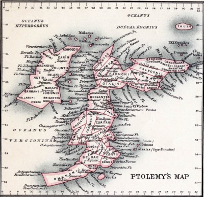
Ptolomey map. Roman Britain.
The details of the Roman administration of Britain are somewhat imperfectly known to us. The province remained one till A. D. 210, when Severus formed two provinces of uncertain area, Britannia Inferior, including Eburācum and the Wall, and Superior, including Deva and Isca, the dividing line probably being drawn from the Mersey to the Humber; it is doubtful if this division remained in force long after the death of Severus.
In 297 it was subdivided by Diocletian, like the rest of the Empire, and four provinces were formed, Prima (which included Cirencester), Secunda, Flavia Caesariensis, and Maxima (the two latter probably in the north), but their frontiers are wholly unknown. In 369 a fifth province, Valentia, was formed, but its position is equally uncertain. The governor of the undivided province was a legatus pro praeto, who ranked high among provincial governors, and as commander of a large army was regularly a consularis; this pre-eminence continued after the division of the province.
The garrison of the island, during the second and third centuries, comprised (a) three legions stationed at Eburacum (vi), Deva (xx), and Isca (ii Augusta), and (b) a strong force of ‘auxiliary’ cohorts and alae, recruited largely in Germany, stationed along the Wall and the roads leading to it. The district between the Humber and the Tyne (conjecturally Britannia Inferior) was almost wholly given up to these troops, and formed a vast military frontier.
The south was less heavily garrisoned; the legions at Deva and Isca secured two inlets into Britain against the Irish, and in the fourth century the nine forts along the ‘Saxon shore’ (from Branodūnum to, perhaps, Porchester) defended the south- east against the Saxons.
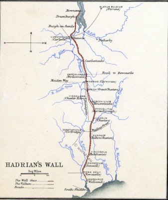
Hadrians Wall
Beside this military element, the civil element was comparatively insignificant. Coloniae were founded, so far as we know, only at Camulodunum (A. D. 52), Glevum (A.D. 95-7), Lindum, Eburacum; a municipium only at Verulamium; and none of these towns flourished like the Roman municipal foundations on the continent.
A certain number, of small Romano-British towns, however, rose to some prosperity, though we have no evidence that they obtained municipal status: such are Ratae, Corinium, Aquae Sulis, Venta Silurum, and especially the towns of the early Romanized south-east, Calleva, Venta Belgarum, Regni, &c. There were ‘villas’ in abundance, notably in Mid Gloucestershire and West Sussex, and the mass of the native population was perhaps grouped round these local centres for purposes of trade or agriculture.
The native population under Roman rule was not wholly Romanized. The Brigantes remained unquiet till the end of the second century. During the second and third centuries British recruits were rarely utilized for the garrison of Britain, but were sent to Germany, which, in turn, provided troops for Britain. In the third and fourth centuries Irish immigration probably increased the Celtic elements of the west coast. But the richer classes and the dwellers in towns were Romanized, and at the commencement of the fifth century the higher culture and political institutions of Britain were predominantly Latin.
The resistance to the Picts, Scots, and Saxons was carried on by a Romano-British population. It is some credit to Roman rule that this resistance, though disparaged by Gildas, was in fact at least as desperate and prolonged as that shown to the barbarians elsewhere in the Empire.
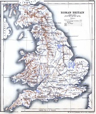
Of the accompanying maps the principal one has been constructed with the idea of providing a map suitable to students of Roman Britain, so far as such a map can be drawn up in the present state of our knowledge. The names and roads contained in it profess only to be a selection of the most certain and most interesting. Ptolemy’s Map has been adapted, by permission, with very slight alteration from the excellent map communicated by Mr. H. Bradley to the London Society of Antiquarie (Archaeologia, xlviii, 1884). The map of Hadrian’s Wall will explain itself, so far as explanation of the complicated mural problems is at present possible.
The following list of places contains all the names in the larger map and in that of Hadrian’s Wall, with a few notes. Tribes are distinguished by small capitals. Modern names are printed in italics, those of which the Roman name is unknown being marked with an obelus, The Wall is indicated by W.
List of names, places, tribes.
- Aballava. Fort, now Pap castle (Cumb.).
- Abus. River, perhaps the Humber.
- Aesica. Great Chesters on vV.
- ♰ Adel. Near Leeds (Yorks.), +
- ♰ Alchester. Near Bicester (Oxon.).
- Amboglanna. Fort at Birdoswald on W.
- Anderida. Fort on the Littus Saxonicum, at Pevensey (Suss.).
- Aquae Sulis. Bath.
- ♰ Ardoch. Fort north of Antonine’s Wall.
- ATREBATES. In Berks. and Hants. 1
- BELGAE. In Wilts. and Hants.
- ♰ Bewcastle. Fort north of W.
- ♰ Bignor. Large villa near Chichester (Regni).
- Blatum Bulgium 2. Fort at Birrens, north of W., near Ecclefecchan.
- Bodotria. (Boderia in Ptolemy). Firth of Forth.
- Borcovicium. Fort at Housesteads on W.
- ♰ Bossens. Small fort in Cornwall, probably occupied temporarily.
- ♰ Bowness. Fort on W.
- ♰ Brading. Large villa (I. of Wight).
- Branodunum, Fort on the Littus Saxonicum, now Brancaster (Norfolk).
- Bravoniacum (or Brovonacae). Fort, now Brougham (Cumb.).
- ♰ Brecon. Fort at Ygaer, near Brecon.
- Bremenium. Fort north of W., now High Rochester.
- Bremetennacum. Fort, now Ribchester (Lanc.).
- BRIGANTES. In Yorkshire, &c.
- Brocavum. Fort, now Kirby Thore (Cumb.).
- Brough (1) Fort in Derbyshire, perhaps Anavio 3.
- ” ” (2) See Verterae.
- ♰ ” ” (3) On Humber.
- ♰ Burgh-on-Sands. Fort on W.
- Buxton. In Derbyshire, perhaps Aquae.
- Calcaria. Tadcaster, s. of York.
- Calleva. Silchester, Romano-British town of the Atrebates.
- Cambodūnum, Fort at Slack, near Huddersfield (S. Yorks.).
- Camboricum (more probably Carnborĭtum = crooked ford). Probably Grantchester, near Cambridge 4.
- Camulodũnum. Colchester, a colonia.
- Canovium. Fort at Caerhŷn, near Conway, N. Wales.
- CANTII. In Kent 5.
- ♰ Cappuck. Fort in Scotland, near Jedburgh.
- ♰ Castlesteads. Fort on W.
- Cataractonium. Fort in N. Yorks., now Catterick.
- CATUVELLAUNI. Tribe in eastern Midlands.
- Causennae. Now Ancaster (Linc.).
- ♰ Chedworth. Large villa near Cirencester.
- ♰ Chester-le-street. Fort south of W.
- ♰ Chesterford. Town in Essex.
- Cilurnum. Fort on W., now Chesters.
- Clausentum. Bittern, near Southampton.
- Condercum. Fort on W., now Benwell, near Newcastle.
- Corinium. Cirencester, town of the Dobuni, also called Durocornovium.
- CORITANI. In Leicestershire.
- CORNAVII. In Shropshire.
- Corstopitum. Fort, &c. near W., now Corbridge.
- ♰ Cramond. Fort near Edinburgh.
- Cunetio. Village near Marlborough 6.
- Damnonium Prom. The Lizard.
- Danum. Fort, probably Doncaster (S. Yorks.).
- DECEANGI 7. Small tribe in Flintshire.
- DEMĚTAE. In S. Wales (later Dyfydd).
- ♰ Derby. Village (in the suburbs).
- Deva. Fortress of Twentieth Legion, now Chester; river, now Dee.
- DOBŪNI 8. In Gloucestershire; see Corinium.
- ♰ Dorchester. Town (Oxon.).
- Dorchester, Town (Dorset); see Durnovaria.
- ♰ Drumburgh. Fort on W.
- Dubrae. Dover, fort on the Littus Saxonicum.
- DUMNONII (or DAMNONII). In Cornwall 9.
- ♰ Dunwich. In Suffolk.
- Durnovaria. Town of Durotriges, now Dorchester (Dorset).
- Durobrīvae, (1) Castor and Chesterton on the Nen; (2) Rochester (Kent).
- Durocornovium. See Corinium.
- Durolipons. Probably Godmanchester (Hunts.).
- DUROTRIGES 10. In Dorset.
- Durovernum, Town of the Cantii, now Canterbury.
- Ebchester. Fort south of \V.
- Eburācum. York, a colonia and fortress of the Sixth Legion.
- [Etocētum. Incorrect spelling for Letocētum (Lichfield).]
- ♰ Felixstowe. Perhaps a fort, on the Essex coast.
- Gariannonum. Fort on the Littus Saxonicum, now Borough Castle on the Yare (Norf.).
- Cessoriācum. Boulogne, later Bononia 11.
- Glevum. Gloucester, a colonia established by Nerva.
- Gobannium. Abergavenny (Monm.).
- ♰ Gretabridge. Fort in N. Yorks.
- Habitancium (or Habitancum). The probable name of a fort at Risingham, north of W.
- ♰ Hard Knot. Fort in Cumberland.
- Hunnum. Fort on W., now Halton Chesters.
- ICENI. In Norfolk and Suffolk.
- ♰ Ilchester. Town in Somerset.
- Ilkley. Town or fort in Yorkshire, perhaps Olicana (Ptolemy).
- ♰ Irchester. Fort (?) on the Nen.
- Isca Dumnoniorum. Exeter.
- Isca Silurum. Caerleon-on-Usk (Monm.), fortress of the Second Legion.
- Isurium. Town at Aldborough (Boroughbridge) near York.
- Itūna. Solway 12.
- Ivernia. Ireland.
- ♰ Lancaster. Fort.
- Lanchester. Fort in Durham, probably Longovicium.
- Lavatrae. Fort, now Howes (N. Yorks.).
- Letocētum, Wall, near Lichfield 13.
- Leucārum. Loughor (Welsh Llychwr) , S. Wales.
- Lindum. Lincoln, a colonia (first a fortress).
- Londinium. London (in fourth century Augusta).
- Luguvallium. Fort and small town near W., now Carlisle (old form Caerluel).
- ♰ Lydney. Temple of Nodon, in Forest of Dean.
- MAEATAE. In Scotch Lowlands.
- Magnae 14, (1) Fort on W, now Carvoran. (2) Small town, now Kenchester (Heref.).
- ♰ Malton. Town in E. Yorks.
- Mancunium. Fort at Manchester.
- Manduessedum. Mancetter, in the Midlands.
- Maridūnum. Caermarthen, S. Wales.
- ♰ Melandra Castle. Fort between Manchester and Brough (1), near Glossop.
- Metaris. Probably the Wash.
- Mona. Anglesea (also used for the Isle of Man).
- Monapia. Isle of Man (? Menapia).
- ♰ Moresby. Fort on the Cumberland coast.
- Moricambe. Perhaps Morecambe Bay, Lancashire (the present name is modern).
- ♰ Netherby. Fort north of W.
- ♰ Newstead. Fort north of W. (near Melrose).
- Nidum. Neath, S. Wales.
- Ocĕlum Prom. Perhaps Spurnhead.
- Octapitarum. St. David’s Head.
- Old Carlisle. Fort in Cumberland possibly Petriana.
- ORDOVĪCES 15. In North and Mid Wales.
- Othonae. Fort on the Littus Saxonicum, now Bradwell, Essex: Anglo-Saxon Ithanceaster.
- Overborough. Fort in Lancashire, perhaps Galacum.
- Pons Aelii. Fort on W., now Newcastle-on-Tyne.
- ♰ Porchester, Fort, possibly Portus Adurni on the Littus Saxonicum.
- Portus Gabrantovicorum. Perhaps Filey, Yorks.
- Portus Lemanae. Fort on the Littus Saxonicum, now Lymne in Kent.
- Procolitia. Fort on W. now Carrawbrough.
- Ratae. Town of the Coritani, now Leicester.
- ♰ Ravenhill. Fort (fourth century), on Yorks coast.
- Regni (or Regnum) 16. Town, now Chichester (Sussex).
- Regulbium. Fort of the Littus Saxonicum, now Reculver.
- Rutupiae, Fort of the Littus Saxonicum, now Richborough.
- Sabrĭna. River Severn.
- ♰ Sarn Helen. Name of Roman road in Wales.
- Segedūnum. Fort on W., now Wallsend.
- Segelocum 17. Near Lincoln, now Littleborough.
- Segontium 18. Fort, now Carnarvon (N. Wales).
- SILURES. In S. Wales and Monmouthshire.
- Sorbiodūnum. Old Sarum 19, near Salisbury.
- ♰ South Shields. Fort at mouth of Tyne.
- Spinae. Speen, near Newbury, Berkshire.
- ♰ Stanegate. Road south of W. and parallel to it.
- ♰ Stanwix. Fort on W.
- Tanatus. Isle of Thanet (Kent).
- Thamēsa 20. River Thames.
- TRINOVANTES. In Suffolk and Essex.
- Trisantona. Perhaps the name of the Trent and of other British rivers.
- Uxellodūnum. Fort in Cumb., near Maryport.
- Vectis. Isle of Wight.
- Venonae, High Cross, Staff.
- Venta Belgarum. Town, now Winchester.
- Venta Icenorum. Town near Norwich.
- Venta Silurum. Town, now Caerwent, near Caerleon (Isca).
- Verterae. Fort, now Brough-under-Stainmore (Westmorland).
- Verulamium. Said by Tacitus to be a municipium, near St. Albans.
- Vindobala. Fort on W., now Rutchester.
- Vindogladia. Village, now Woodyates (Dorset).
- Vindolana. Fort near W., now Chesterholm.
- Vinovia. Fort, now Binchester (Durham).
- Viroconium (possibly more correctly Vriconium). Wroxeter.
- Voreda. Fort south of Carlisle, now Plumpton Wall.
- ♰ Wilderspool. Fort (Cheshire).
- ♰ Windermere. Fort (Westmorland).
- ♰ Woodchester. Villa in Gloucestershire.
By F. HAVERFIELD.
- 1 The Segontiaci (see note 18) and Bibroci (? Berks) of Caesar may be clans of this tribe.
- 2 Perhaps more correctly Blatobulgium.
- 3 Compare the river name Noe.
- 4 The name Cambridge, however, has nothing to do with Camboricum,
- 5 The Bodūni, conquered A. D. 43, may be a clan of this tribe.
- 6 Hence perhaps Kennet.
- 7 The form of the name (Deceangi, Decangi, Ceangi) is uncertain.
- 8 Some would spell Dobunni, Magnae (2) may have also been one of their towns.
- 9 The name recurs in Scotland (Ptolemy).
- 10 Hence Dorset, Dorchester.
- 11 Probably Caesar’s portus Itius.
- 12 Solway may be derived from Selgovae (Ptolemy): Ituna may survive in Eden.
- 13 The first half of the present name is derived from the ancient Celtic name (‘Greywood’).
- 14 The name occurs only in abl. Magnis: Magnae is accepted as nom. in ‘C.l.L.’ vii, but Professor Rhŷs connects the word with ‘maen’ a stone (masc.), and suggests Magni. The Roman name of Kenchester may survive in ‘Magonsete,’ the oldest form of the name of the West-Saxon Magasaetas, who occupied Herefordshire.
- 15 The name probably survives in Dinorwig, near Snowdon.
- 16 The name might possibly be the Latin regnum, referring to the vassal kingdom of Cogidubnus.
- 17 Incorrectly spelt Agelocum.
- 18 The name recurs at Calleva (see note 1),
- 19 The name Sarum arose from misreading of a contraction, not from the ancient name.
- 20 The Roman spelling and the quantity of the e vary.
Source: Historical atlas of modern Europe from the decline of the Roman empire: comprising also maps of parts of Asia and of the New world connected with European. Author: Poole, Reginald Lane. Edited by Reginald Lane Poole. Publisher: Oxford: Clarendon Press; London; New York: H. Frowde.
Related
Continuing
- Roman Costume and Fashion History.
- Roman clothing in its diversity and development.
- The early toga. Former roman clothing. 700 BC. – 500 BC.
- The Toga and the manner of wearing it.
- The toga of a Roman senator. The armor of a Roman general.
- The costume of the Roman women. Republican Rome.
- The usual Roman garment during the Republican Rome.
- Roman Republic. Senator in the toga. A commoner in the paenula.
- The Togatus and the Roman ladies of the imperial period.
- The Roman Tunica or the Dorian and the Ionian chiton.
- Musical instruments. Wind and Stringed instruments of ancient Rome.
- Roman headgear and hairdos of antiquity.
- The Roman army. The legionary soldier. Equipment, assault weapons.
- Military of ancient Rome. Roman legions. Field signs. The legionary eagle.
- Roman soldiers and gladiators. Function, armor and armament.
- The Roman legionary. Reconstructed after reliefs of the Trajan’s Column.
- The Lictor panel. A stately Roman lictor in a rich costume.
- The Roman Paenula. The cowl or hood. Traveling cloak.
- Pontifex Maximus. Roman high priest of antiquity. Collegium Pontificum.
- An Augur. Roman official priesthood.
- The Rex Sacrorum also known as Rex Sacrificulus.
- Religious sacrificial ceremonies of Romans in ancient times.
- A quadriga. Greek-Roman Gods. The ancient greek-roman culture.
- The Clothing of the Vestal Virgins. The Cult of Vesta in ancient Rome.
- Shoes of antiquity. Sandals, closed footwear of the ancient world.
- The Etruscans. Culture, costumes, warriors in Etruria.
- Greek-Roman furniture. Throne chair, Bisellium, Sella castrensis.
- Greek-Roman art. Mosaics, painted bas-reliefs and wall paintings.
- A quadriga. Greek-Roman Gods. The ancient greek-roman culture.
- The Roman Ornament. Corinthian and Composite Capitals. The Acanthus.
- Rome. The atrium. Interior of an ancient Roman palace.
- Pompeji. Roman architecture. The Pompeian House. The Atrium.
- The Roman Pantheon, a temple to all the Gods.
- Britain under Roman rule. Celt and Roman. England 43 BC to 440 AD.
- Hadrians Wall. Roman Britain. Maps, Places, Tribes.
- The Gallic and Gallo-Roman costume period.
Discover more from World4 Costume Culture History
Subscribe to get the latest posts sent to your email.

